
Bestand:2000 Atlantic hurricane season summary map.png

Grootte van deze voorvertoning: 800 × 495 pixels. Andere resoluties: 320 × 198 pixels | 640 × 396 pixels | 1.024 × 634 pixels | 1.280 × 792 pixels | 2.560 × 1.585 pixels | 4.000 × 2.476 pixels.
Afbeelding in hogere resolutie (4.000 × 2.476 pixels, bestandsgrootte: 6,21 MB, MIME-type: image/png)
| Dit is een bestand van Wikimedia Commons, een verzameling van vrije inhoud die door de Wikimedia Foundation wordt gehost. Onderstaande beschrijving komt van de beschrijving van het bestand daar. |
| Beschrijving |
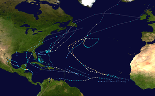
English: This map shows the tracks of all tropical cyclones in the 2000 Atlantic hurricane season. The points show the location of each storm at 6-hour intervals. The colour represents the storm's maximum sustained wind speeds as classified in the Saffir-Simpson Hurricane Scale (see below), and the shape of the data points represent the type of the storm.
Tropical depression (≤38 mph, ≤62 km/h)
Tropical storm (39–73 mph, 63–118 km/h)
Category 1 (74–95 mph, 119–153 km/h)
Category 2 (96–110 mph, 154–177 km/h)
Category 3 (111–129 mph, 178–208 km/h)
Category 4 (130–156 mph, 209–251 km/h)
Category 5 (≥157 mph, ≥252 km/h)
Unknown
Storm type |
| Bron | Created using Wikipedia:WikiProject Tropical cyclones/Tracks. The background image is from NASA [1]. The tracking data is from the National Hurricane Center's Atlantic hurricane database |
| Auteur | Supportstorm |

|
Dit bestand kan geactualiseerd worden om nieuwe informatie te weerspiegelen. Indien je een specifieke versie van het bestand wil gebruiken zonder dat er nieuwe updates plaatsvinden, dien je die betrokken versie te uploaden als een afzonderlijk bestand. |
| Dit werk vrijgegeven in het publieke domein door de auteur, Supportstorm. Dit is wereldwijd van toepassing. In sommige landen is dit wettelijk niet mogelijk; in die gevallen geldt: Supportstorm staat iedereen toe dit werk voor eender welk doel te gebruiken, zonder enige voorwaarden, tenzij zulke voorwaarden door de wet worden voorgeschreven. |
Bestandsgeschiedenis
Klik op een datum/tijd om het bestand te zien zoals het destijds was.
| Datum/tijd | Miniatuur | Afmetingen | Gebruiker | Opmerking | |
|---|---|---|---|---|---|
| huidige versie | 14 jan 2020 08:17 | | 4.000 × 2.476 (6,21 MB) | Supportstorm | Track generator created |
| 11 apr 2019 01:28 |  | 3.000 × 1.854 (5,04 MB) | Es204L | dimensions | |
| 9 jun 2013 20:58 |  | 3.000 × 1.996 (4,53 MB) | Supportstorm | {{Hurricane season auto track map|start=|end=|source=ATL|type=hurricane|basin=Atlantic|year=2000|author=Supportstorm}} |
Bestandsgebruik
Geen enkele pagina gebruikt dit bestand.
Globaal bestandsgebruik
De volgende andere wiki's gebruiken dit bestand:
- Gebruikt op en.wikipedia.org
- Hurricane Alberto (2000)
- 2000 Atlantic hurricane season
- Hurricane Keith
- Template:2000 Atlantic hurricane season buttons
- Tropical Storm Leslie (2000)
- Hurricane Gordon (2000)
- User:Icelandic Hurricane/Sandbox
- Hurricane Debby (2000)
- Tropical Storm Helene (2000)
- Hurricane Michael (2000)
- Tropical Storm Beryl (2000)
- Hurricane Isaac (2000)
- Hurricane Florence (2000)
- Wikipedia:Good topics
- Timeline of the 2000 Atlantic hurricane season
- Wikipedia:Featured and good topic candidates/2000 Atlantic hurricane season/archive1
- Wikipedia:Featured and good topic candidates/Featured log/February 2014
- Wikipedia:Featured topics/2000 Atlantic hurricane season
- Wikipedia:Featured and good topic candidates/Good log/February 2014
- Tropical cyclones in 2000
- Gebruikt op es.wikipedia.org
- Gebruikt op fr.wikipedia.org
- Gebruikt op pt.wikipedia.org
- Gebruikt op simple.wikipedia.org