
Bestand:Map at millstaetter see.svg

Afmetingen van deze voorvertoning van het type PNG van dit SVG-bestand: 800 × 453 pixels Andere resoluties: 320 × 181 pixels | 640 × 363 pixels | 1.024 × 580 pixels | 1.280 × 725 pixels | 2.560 × 1.451 pixels | 1.313 × 744 pixels.
Afbeelding in hogere resolutie (SVG-bestand, nominaal 1.313 × 744 pixels, bestandsgrootte: 124 kB)
| Dit is een bestand van Wikimedia Commons, een verzameling van vrije inhoud die door de Wikimedia Foundation wordt gehost. Onderstaande beschrijving komt van de beschrijving van het bestand daar. |
| Beschrijving |
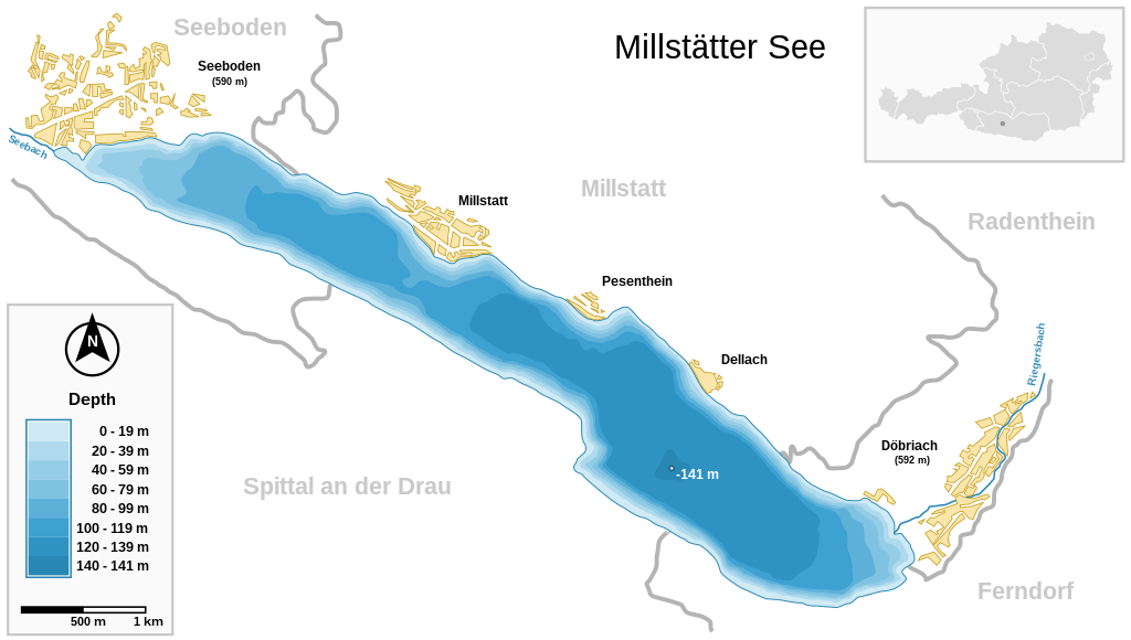
Deutsch: Millstätter See (Kärnten, Österreich) und wichtigste Ortschaften Seeboden / Millstatt / Pesenthein / Dellach / Döbriach
English: Millstätter See (Carinthia, Austria) with surrounding towns.
Français : Carte du lac Millstätter (Carinthie, Autriche) et des villes qui l'entourent. |
| Datum | |
| Bron | |
| Auteur | Michael Glanznig (Mglanznig) |
| Toestemming (Hergebruik van dit bestand) |
Creative Commons Attribution ShareAlike 2.0 Austria |
| Andere versies | png |
| SVG ontwikkeling | This map is translated using SVG switch elements: all translations are stored in the same file. |
| Cameralocatie | | Deze en andere afbeeldingen in: OpenStreetMap |
|---|
|

Deze afbeelding is geselecteerd als afbeelding van de dag op 4 augustus 2006. De afbeelding heeft de volgende beschrijving: Andere talen:
Cymraeg: Y Llyn Millstät (Millstätter See) (Carinthia, Awstria) gyda'i threfau amgylchoedd. Magyar: A Millstatti-tó (Karinthia, Ausztria) a környező falvakkal. Polski: Mapa Millstätter See (Karyntia, Austria) wraz z otaczającymi je miastami. Português: Millstätter See (Caríntia, Áustria) e cidades circundantes.. Русский: Мильшттское озеро (Millstätter See) в Каринтии, в Австрии: схема озера с прилежащими городами العربية : بحيرة ميلستيتير (كارينثيا النمسا) و البلدات المحيطة. |
Ik, de auteursrechthebbende van dit werk, maak het hierbij onder de volgende licentie beschikbaar:
Dit bestand is gelicenseerd onder de Creative Commons-licentie Naamsvermelding-Gelijk delen 2.0 Oostenrijk
- De gebruiker mag:
- Delen – het werk kopiëren, verspreiden en doorgeven
- Remixen – afgeleide werken maken
- Onder de volgende voorwaarden:
- naamsvermelding – U moet op een gepaste manier aan naamsvermelding doen, een link naar de licentie geven, en aangeven of er wijzigingen in het werk zijn aangebracht. U mag dit op elke redelijke manier doen, maar niet zodanig dat de indruk wordt gewekt dat de licentiegever instemt met uw werk of uw gebruik van zijn werk.
- Gelijk delen – Als u het werk heeft geremixt, veranderd, of erop heeft voortgebouwd, moet u het gewijzigde materiaal verspreiden onder dezelfde licentie als het oorspronkelijke werk, of een daarmee compatibele licentie.

Bestandsgeschiedenis
Klik op een datum/tijd om het bestand te zien zoals het destijds was.
| Datum/tijd | Miniatuur | Afmetingen | Gebruiker | Opmerking | |
|---|---|---|---|---|---|
| huidige versie | 27 mrt 2021 12:04 | | 1.313 × 744 (124 kB) | JoKalliauer | 1) width="1050pt" height="210mm" undefined behaviour (90 or 96 dpi) ; 2)<sodipodi:namedview pagecolor="#ffffff" replaced with <circle r="1e4" fill="#ffffff"/> and <rect width="100%" height="100%" fill="#ffffff"/>; 3) fonts replaced by fallback-fonts |
| 10 jun 2019 20:47 |  | 1.313 × 744 (239 kB) | Djiboun | File uploaded using svgtranslate tool (http://tools.wmflabs.org/svgtranslate/). Added translation for fr. | |
| 16 apr 2006 12:01 |  | 1.313 × 744 (238 kB) | Mglanznig | names for creeks | |
| 15 apr 2006 09:50 |  | 1.313 × 744 (236 kB) | Mglanznig | refinements | |
| 13 apr 2006 23:06 |  | 1.313 × 744 (233 kB) | Mglanznig | more svg rendering errors, praise Inkscape | |
| 13 apr 2006 22:43 |  | 1.313 × 744 (237 kB) | Mglanznig | svg errors corrected | |
| 13 apr 2006 22:35 |  | 1.313 × 744 (236 kB) | Mglanznig | ;Description : {{de|Millstätter See und wichtigste Ortschaften, Kärnten, Österreich}} {{en|Millstätter See with main towns, Carinthia, Austria}} ;Source : {{de|selbst zusammengestellt; Geodaten von [http://www.map24.com Map24] und [http://www.kagis.kt |
Bestandsgebruik
Dit bestand wordt op de volgende pagina gebruikt:
Globaal bestandsgebruik
De volgende andere wiki's gebruiken dit bestand:
- Gebruikt op arz.wikipedia.org
- Gebruikt op be.wikipedia.org
- Gebruikt op ceb.wikipedia.org
- Gebruikt op de.wikipedia.org
- Gebruikt op el.wikipedia.org
- Gebruikt op en.wikipedia.org
- Gebruikt op eo.wikipedia.org
- Gebruikt op fr.wikipedia.org
- Gebruikt op hu.wikipedia.org
- Gebruikt op hy.wikipedia.org
- Gebruikt op ia.wikipedia.org
- Gebruikt op id.wikipedia.org
- Gebruikt op ko.wikipedia.org
- Gebruikt op lv.wikipedia.org
- Gebruikt op nl.wikipedia.org
- Gebruikt op nn.wikipedia.org
- Gebruikt op pl.wikipedia.org
- Gebruikt op pt.wikipedia.org
- Gebruikt op ru.wikipedia.org
- Gebruikt op ru.wikinews.org
- Gebruikt op su.wikipedia.org
- Gebruikt op uk.wikipedia.org
- Gebruikt op www.wikidata.org